https://innews.media/uploads/news/2026-04/_innews_d9aa792f6f6ddb46a08780a33_o.jpg
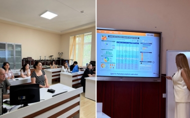
A master class on “The Use of Satellite Data in Urban Planning and Cadastre” was held at the Faculty of Geography of Baku State University (BSU) as part of the “Year of Urban Development and Architecture.” The session was delivered by Elkhan Aleskerov, a specialist from the Azerbaijan Space Agency (Azercosmos).
Dean of the Faculty, Professor Maghsud Gojamanov, emphasized the growing importance of satellite data, remote sensing, and geographic information systems in modern urban planning and cadastral work.
In his presentation, Elkhan Aleskerov spoke about satellite data processing, real-time Earth observation, and the application of geospatial technologies in city planning. He also highlighted the use of satellite data in environmental monitoring, disaster assessment, and analysis of the urban heat island effect.
He further presented Azercosmos projects, student internship opportunities, and an Earth observation competition.
The event also featured contributions from faculty members, including Associate Professors Saleh Nagiyev, Ramiz Akhlimanov, Irada Aliyeva, and Senior Lecturer Mubariz Orujov.


Ən son xəbərləri səhifəmizdən də izləyin